Events
Comments Off on EventsApril Events
Sunday, April 5th
HIKE – Holland Creek and the Rotary lookout. A scenic hike alongside running water. About 7 km and 150 m elevation gain. Meet at ArtSpring to car pool, departing at 11:20 to drive on the 12:05 ferry to Crofton, return likely on the 4:50 ferry.
Tuesday, April 7th
HIKE – Jack Little will lead a hike in Channel Ridge. Meet at ArtSpring to car-pool, departing at 9:45 or at the trailhead at the end of Pringle Farm Rd to set out at 10:05. Moderate elevation gain on well-marked trails with views West and East over Stewart and Trincomali Channels.
WALK – Sue will lead a waterfall walk on Mount Tuam from the end of Isabella Point (not Maxim). Take the right fork near the end of the road to stay on Isabella Point Rd. The walk is up hill until lunch past many waterfalls. Good boots and poles are recommended, Then it’s all downhill after lunch. Carpool departing ArtSpring at 10 a.m.or meet at the end of Isabella Point Road at 10:20
RAMBLE – Ramblers will meet at ArtSpring at 10:30 and carpool to the trailhead at the end of
Seymour Heights and ramble down hill to 456 Dukes Rd and eat our lunches on my deck if it’s nice or in my basement in front of the wood stove if it’s cold.
Sunday, April 12th
HIKE – Lee Rd Trail to the Little View summit on the flanks of Mt Maxwell. Steep to start, 300 m elevation gain, poles useful. Meet at ArtSpring to car pool, departing at 1:00 or at the trailhead on Lee Rd to set out at 1:20.
Tuesday, April 14th
HIKE – CHANGE OF PLAN The weather forecasts all agree that tomorrow morning will bring rain. So, I think we should not do the planned hike up Mt Bruce – what would be the point?
Instead, I propose a shorter hike, 2 – 3 hours in total, from the end of Maxham Road to and around the waterfall in the ecological reserve..
Meet at ArtSpring at 0945 to carpool or at Drummond Park at 1000 or at the starting point at the end of Maxham Road. Maxham is the last road on the left off Isabella Point Rd.
CANCELLED Ashley Hilliard will lead a hike through the Alvin Indridson Nature Reserve and on to the Mt Bruce summit. Meet at ArtSpring to carpool in vehicles that can travel Musgrave Road, departing at 09:45. Or join at meeting place: Drummond Park at 1005. We will organize carpooling from there. Hike is weather dependent and will be confirmed by email the evening before.
WALK- Bill will lead a moderate walk from the parking area at Burgoyne Park to Daffodil Point. Lunch with fine views at the Point. Distance – about 3 km. Elevation gain < 100m
Carpool departing ArtSpring at 10 a.m.or meet at the Burgoyne parking area at 10:20 AM.
RAMBLE – CANCELLED TODAY
Sunday, April 19th
HIKE – Bold Bluff. Meet at ArtSpring to car pool, departing at 1:00 pm or at the parking area at Burgoyne Bay to set out at 1:20. Rough trail, muddy in places, about 120 m elevation gain, 6 km.
Tuesday, April 21st
HIKE – Lynn Thompson will lead a hike on Mt Tzouhalem to see the wildflowers. Meet at Portlock Park to car pool departing at 8:40 to drive on the 9:35 ferry.
WALK – Carron will lead a moderate walk on the Reginald Hill Conservation Area with lunch at the lookout. The route is a gradual climb. Meet at ArtSpring for 10:00 am departure or at Clarinda Road at 10:20. Park on Clarinda Road near the intersection with Bridgeman Road. Carpool departing ArtSpring at 10 a.m.or meet at the end of Isabella Point Road at 10:20 AM.
RAMBLE – Paul will lead. Meet at ArtSpring at 10:30 to carpool to Drummond to carpool again to where we can walk to the waterfall then back to Drummond for lunch.
Take your lunch,
Sunday, April 26th
HIKE – Hope Hill and the White Pine trail. 300m elevation gain in short steep steps, plus some small ups and downs, leading to a spectacular viewpoint. Trail rough in parts due to deadfall and erosion, poles useful for the steep descents; 3½ to 4 hours. Meet at ArtSpring to car pool, departing at 1:00 pm or at the parking area at Drummond Park to limit number of vehicles, setting out at 1:20.
Tuesday, April 28th
HIKE – Jenny and Nick Coghlan will lead a hike in Channel ridge to see the wildflowers. Meet at ArtSpring to car-pool, departing at 9:40, or meet at the trailhead at the top of Broadwell to set out at 10:00. Note the detour around Sunset Drive and Channel Ridge Drive to reach the top of Broadwell.
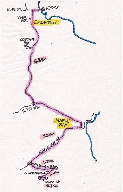
WALK – Lynn Thompson will lead a walk on Mt Tzouhalem to view the wildflowers, Then we will drive back toward Maple Bay, and turn onto Genoa Bay Road for 5 km to Stoney Hill Road. Travel uphill on Stoney Hill Road for about 1 km to a parking area for Stoney Hill Park for lunch and walk the loop trail which features spectacular views over Samsum Narrows and Salt Spring Island.
See April 21 hike description in Events on our website https://saltspringtnc.ca/ for the driving map from Crofton to Mt. Tzouhalem wild flower reserve.
Meet at Portlock Park to car pool departing at 8:40 am to drive onto the 9:35 ferry.
Anticipated return – 3:35 ferry
The cost per passenger (distance plus vehicle fare) is $20 per person, paid to your driver. Participants are responsible for paying their own ferry passenger fare.
RAMBLE – Meet at ArtSpring at 10:30 and ramble through Mouat’s Park and find a restaurant in Ganges for lunch.
MAY EVENTS
Walk Leaders are needed for May 5 and 26 June 2, 9 and 16.
The Strawberry Festival on June 23 is WALKERS responsibility this year. Please reply to Sheila sspence@telus.net if you can assist. Except for sourcing and picking up the strawberries, the activity takes place on June 23rd starting at 10:00 am.
Sunday, May 3rd
HIKE- Crofton Lake and Breen Lake.. Meet at ArtSpring to car pool, departing at 11:40 to walk on the 12:05 ferry to Crofton, return likely on the 4:50 ferry.
Tuesday, May 5th
HIKE – Bob Keates will lead a hike on Mt Maxwell starting from Seymour Heights and joining the scenic Rim trail to the summit. A short steep section to start, but mostly gentle slopes thereafter. Meet at ArtSpring to car-pool, departing at 9:45 or at 10:00 at the junction of Seymour Heights and Armand Way. There we will car-pool further before proceeding to the trailhead at Seymour Heights where parking is limited.
WALK- TBA
RAMBLE – An off-Island ramble
Meet at ArtSpring at 10:00 to carpool to the Vesuvius ferry and catch the 10:50 boat to Crofton then drive to the Golf Course parking lot on Henry Road.
Leave cars there and ramble along the Multi Purpose Trail as far as we want then
back to our cars and drive to the Owl’s Nest Restaurant in Chemainus for lunch.
Options for return ferry from Crofton are 12:55 or 2:20
Sunday, May 10th
HIKE- Ruckle Park starting at Beaver Point Hall, meet at ArtSpring to car pool departing at 1:00, or at the trailhead in behind Beaver Point Hall to set out at 1:20.
Tuesday, May 12th
HIKE – Broom pull at Burgoyne Bay to Daffodil Point. Meet at ArtSpring to car pool, departing at 9:45 or at the lower parking area in Burgoyne Bay to set out at 10:05. Bring loppers, clippers, folding saws.
WALK- TBA
RAMBLE – TBA
Sunday, May17th Howard Horel and Andreas Vogt. Meet at ArtSpring to car pool, departing at 9:45 or at the parking area in Mereside Rd to set out at 10:05.
Tuesday, May 19th Joint groups outing to the Clam Garden in Fulford Harbour on the Isabella Point Rd side.
Sunday, May 24th HIKE – Burgoyne Bay trails 22, 23 and 21: meet at ArtSpring to car pool departing at 1:00, or at the trailhead in Burgoyne Bay to set out at 1:20.
WALK – TBA
RAMBLE – TBA
Tuesday, May 26th A volunteer is needed to lead this hike.
WALK – TBA
RAMBLE – TBA
Sunday, May 31st Channel Ridge starting at Broadwell. Meet at ArtSpring to car pool departing at 1:00, or at the trailhead at the top of Broadwell to set out at 1:15.